Location and Background


The study area is located in coastal south-central Alaska.  This region is characterized by mountains up to 6000 feet (1800 meters) high, many glaciers and icefields, and dense coastal forests of hemlock and Sitka spruce.  This section of the northern Gulf of Alaska coastline is rugged and irregular with many bays, fjords and rocky islands.


Prince William Sound forms a major embayment within the northern Gulf of Alaska coastline.  The study site at Nellie Juan Glacier is situated in a fjord system along the western side of the Sound.  The ice of Nellie Juan Glacier originates in the northern Sargent Icefield; a large ice complex that feeds 14 named glaciers and many more smaller ice tongues.


Nellie Juan Glacier is part of the northern Sargent Icefield and shares broad accumulation areas with Falling, Contact, Ultramarine and Princeton glaciers.  Ice in Nellie Juan Glacier flows northeast to reach tidewater at the southwestern edge of Derickson Bay.  Map extract is from U.S. Geological Survey Seward, Alaska, 1:250,000, 1953 (limited revision 1985).


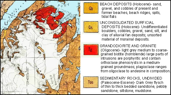
Bedrock geology of the study area is dominated by Oligocene granodiorite and granite of the Nellie Juan pluton (red, Tg).  This pluton has intruded into Paleocene and Eocene sedimentary rocks of the Orca Group (tan, Tos).  Pleistocene and Holocene glacial, fluvial and shoreline deposits overlie bedrock in many areas.  Map extract is from Tysdal, R.G. and Case, J.E., 1979, Geologic Map of the Seward and Blying Sound Quadrangles, Alaska, U.S. Geological Survey Miscellaneous Investigations Map I-1150, scale 1:250,000.


The terminal area of Nellie Juan Glacier can be divided into two distinct zones.  The inner zone around the present terminus is a steep-walled fjord with parallel shorelines eroded between peaks over 1900 feet high.  The outer zone is a broad low elevation area of small bedrock hills, cliffs and recent glacial deposits bordering Nellie Juan lagoon.  Many streams cross this low relief area; in places these streams have been diverted and dammed into ponds and lakes by glacial deposits of the most recent expansion of Nellie Juan Glacier.  The lagoon is separated from Derickson Bay by a prominent spit that marks the 1935 position of the terminus.  Map extract is from U.S. Geological Survey Seward (B-4) Quadrangle, 1:63,360, 1951 (limited revision 1988).


Climate of the study area is characterized by cold winters (mean January temperatures -9 to -6oC), cool summers (mean July temperatures 15 to 17oC) and high precipitation year-round (mean annual precipitation 3 to 5 meters).  This climate is wetter and milder than conditions experienced in interior Alaska because of the strong moderating effects of the adjacent Gulf of Alaska.  Images below are modified from the Spatial Climate Analysis Service, February 2000,
http://www.ocs.orst.edu/prism/state_products/ak_maps.html


  Return to Nellie Juan index page.