OVERVIEW FLIGHT OF NELLIE JUAN GLACIER


Scroll down through this page or click on the map below to take a virtual tour of Nellie Juan Glacier and lagoon.  Each red number links to a photo.


1.  Flying southwest towards the study area we see Derickson Bay in the foreground and Nellie Juan lagoon beyond the prominent spit.  This lagoon is tidal with strong flood and ebb currents passing though the narrow and shallow entrance passage.  Nellie Juan Glacier is out of sight at the back right (southwest) corner of the lagoon.
2.  Looking southwest into Nellie Juan lagoon.  The lagoon-mouth spit was formed at the terminus of Nellie Juan Glacier in 1935 and was uplifted during the 1964 earthquake.  The entrance to the inner fjord where Nellie Juan Glacier terminates today is visible in the right background.  Note the lack of vegetation around the shores of the lagoon; this inner area has only been ice-free for a few decades and vegetation has yet to become re-established.
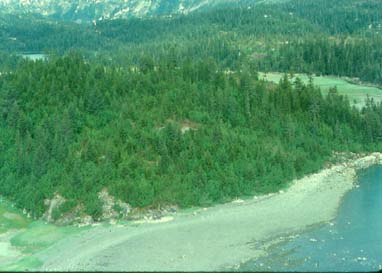
3.  This bedrock knob is directly west of the lagoon mouth spit and was partially covered by ice during the 1840s to 1880s maximum stand of Nellie Juan Glacier.  The line of tall trees (slightly darker green) along the crest of the knob are growing on the terminal moraine, while smaller trees and shrubs have colonized the deglaciated side of the knob in the foreground.
4.  The lagoon mouth passage has been kept open since 1935 by daily scouring of flood and ebb tides.  These currents can be strong and there are many submerged boulders in the channel, creating a significant hazard to boats attempting to enter the lagoon.  Icebergs calved by Nellie Juan Glacier are visible along the inner shore of the spit.
5.  This cirque basin is situated 350 feet above sea level along the western side of the lagoon.  The two lakes are separated by a lateral moraine of Nellie Juan Glacier deposited during the 1840s to 1880s ice maximum.
6.  At the southwestern end of the lagoon we find a small fjord that leads back to the present terminus of Nellie Juan Glacier.  Ice is flowing into the terminal area from the northern Sargent Icefield (around the bedrock ridge on the left side of the view).
7.  Nellie Juan Glacier terminates as a steeply descending ice tongue that is deeply riven by crevasses.  Icebergs are normally quite small and calving activity low, but in July 2000 we did observe a large calving of the full height of the ice cliff.  The resulting wave swept the shores for the full length of the fjord and reached out into the lagoon as a distinct increase in surf activity.  The small dot in the foreground is a small fishing boat.
8.  Turning back to the east we see the main sampling gully of this project.  Meltwater from snow along the south and east sides of the lagoon has eroded through a terrace of glacial deposits (flat area in left side of view).  Many subfossil logs are present within this gully and on the surface of the fan delta that has built out into Nellie Juan lagoon (foreground).  Bedrock is close to the surface here and crops-out to the west of the gully (right side of view), at the waterfall below the pond (background) and at the cascade (left foreground).
9.  The eastern side of the lagoon is a series of moderately level areas separated by steep bedrock cliffs.  The area in the foreground was deglaciated in the 1950s and is now covered by deposits of till, kame and outwash of variable thickness and extent.  Several subfossil logs were found among the rocks at the base of the waterfall in the foreground.


  Return to Nellie Juan index page.